-
在我国城市区域,由于不透水区域占比较大、生产活动复杂、污染来源多样,导致城市内河流污染较为严重。城市面源污染是仅次于农业面源污染的第二大面源污染源[1]。近年来,随着我国城市区域污水收集、截污系统的完善与水质净化厂出水标准的提高,点源污染逐步得到控制,城市面源污染对河流水质的影响越来越凸显,急需对城市内河流面源污染进行负荷量化与影响效应研究,为城市内河流水质进一步改善提供数据支持。
目前,国内对于城市面源污染的负荷量化多利用经验公式进行估算,缺乏较为精确的负荷量化方法。王军霞等[2]通过对内江市不同城市下垫面场次降雨事件平均浓度的研究,估算了内江市全年降雨径流污染中氨氮、COD、TN与TP负荷;杨龙等[3]基于事件平均浓度统计法,估算了2012年北京市城市面源污染物SS、COD等污染物负荷。随着科技水平的提高,西方发达国家开发了大量的分布式水文模型(如SWAT、HSPF、AnnAGNPS模型等[4]),能实现对大尺度流域农业面源污染负荷较高精度的模拟,但对于城市内河流的小尺度流域的城市面源污染的负荷量化与影响效应分析的模型应用研究较为缺乏。李丹等[5]利用改进的SWAT模型,模拟了对太湖流域浙西区的西苕溪流域面源污染TN与TP负荷;赵雪松[6]利用改进的AnnAGNPS模型,实现了对汤河西支流域农业面源污染TN与TP负荷较高精度的模拟。
深圳市观澜河流域为典型的城市内河流集水区域。目前观澜河流域内各水质净化厂出水已达到地表准Ⅳ类,对于区域的截污系统日臻完善,城市面源污染成为影响观澜河水质的主要污染类型。因此,选择深圳市观澜河流域为研究对象,模拟分析城市内河流面源污染的潜在模型——SWAT模型,通过现场勘察调研与地表累积物采样研究,来修正所获取的土地利用数据与模型城镇数据库,从而实现对于观澜河流域的城市面源污染负荷量化与影响效应解析,为我国类似城市内河流的城市面源污染分析提供参考。
全文HTML
-
观澜河流域位于我国南方深圳市中北部,北与东莞市交界,流域总集水面积为189.66 km2。观澜河流域地处北回归线以南,属南亚热带海洋性季风气候,夏季盛行东南风和西南风。观澜河流域多年平均气温为22 ℃,多年平均降雨量为1 825 mm,且降雨量在全年分布不均,4—9月为雨季,降雨量约占全年降雨量的84%。观澜河流域集水区域内包含一条干流及14条一级支流,其中干流观澜河沿河建有的水质处理设施包括龙华水质净化厂一期、二期,观澜水质净化厂一期、二期,坂雪岗水质净化厂、清湖人工湿地与观澜河口调蓄池,是观澜河主要的点源输入与补水水源。观澜河流域地理位置与流域水系分布如图1所示。
-
SWAT模型是常见的面源污染分析模型,其组成包括降雨模拟、产汇流、河流水质扩散等模块[7]。SWAT模型因具有农药/杀虫剂组件与农业管理组件,因此,常被运用于模拟流域农业面源污染,而很少用于城市面源污染的研究。通过《ArcSWAT 2009用户指南》[8]以及《SWAT 2009输入输出文件手册》[9],发现2009以上的版本的SWAT模型具有城镇数据库,已完善了流域土地利用数据与模型城镇数据库,可以用SWAT模型模拟流域城市面源污染。SWAT模型城镇数据库的关键参数[9]如表1所示。
本研究通过对研究区域地表累积物的监测分析确定DIRTMX、TNCONC、TPCONC与TNO3CONC的取值。目前,通常的地表累积物采样方法有2大类:干式采样法和湿式采样法[10]。干式采样法根据使用工具可以细分为用毛刷或者扫帚清扫法与用吸尘器真空采样法。湿式采样法是先利用去离子水清洗地面,在通过真空吸尘机吸取泥水混合样[11]。本研究采用羊毛刷与800 W德国卡赫真空吸尘器对研究区域进行干式采样,其采样过程如下。
1) 在选定的采样区域沿街道边石布点采样,根据采样区域面积确定采样点数,每个区域布点不少于5个,在采样处放置自制的1.0 m×1.0 m的采样框,在框内采集。
2) 采样时,先用吸尘器横竖交叉吸取框内灰尘,然后再用毛刷往复清扫框内地表,以使紧密附着在地表的颗粒物脱离,再使用真空吸尘器吸取框内灰尘,以此重复3~5次。
3) 将真空吸尘器集尘袋内收集的地表灰尘移入无菌采样袋内并贴好标签。
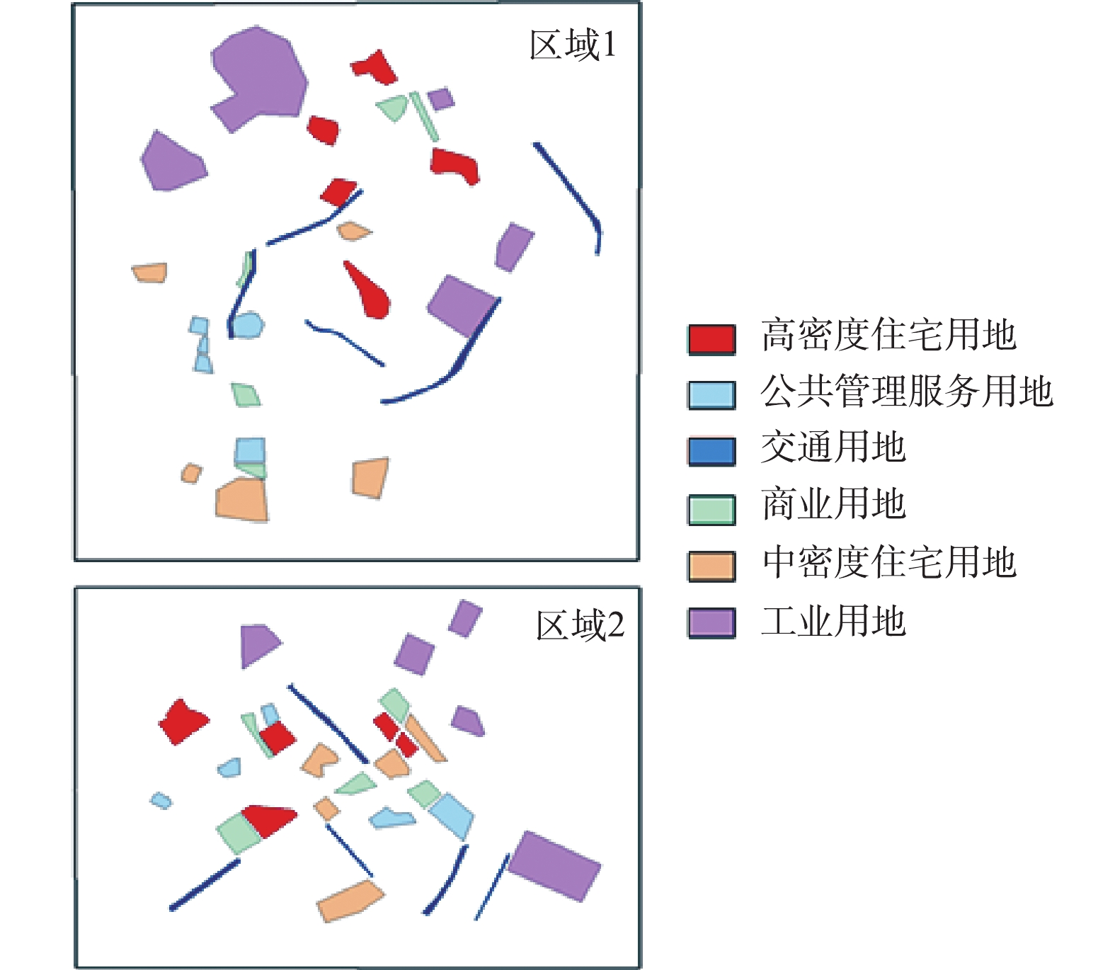
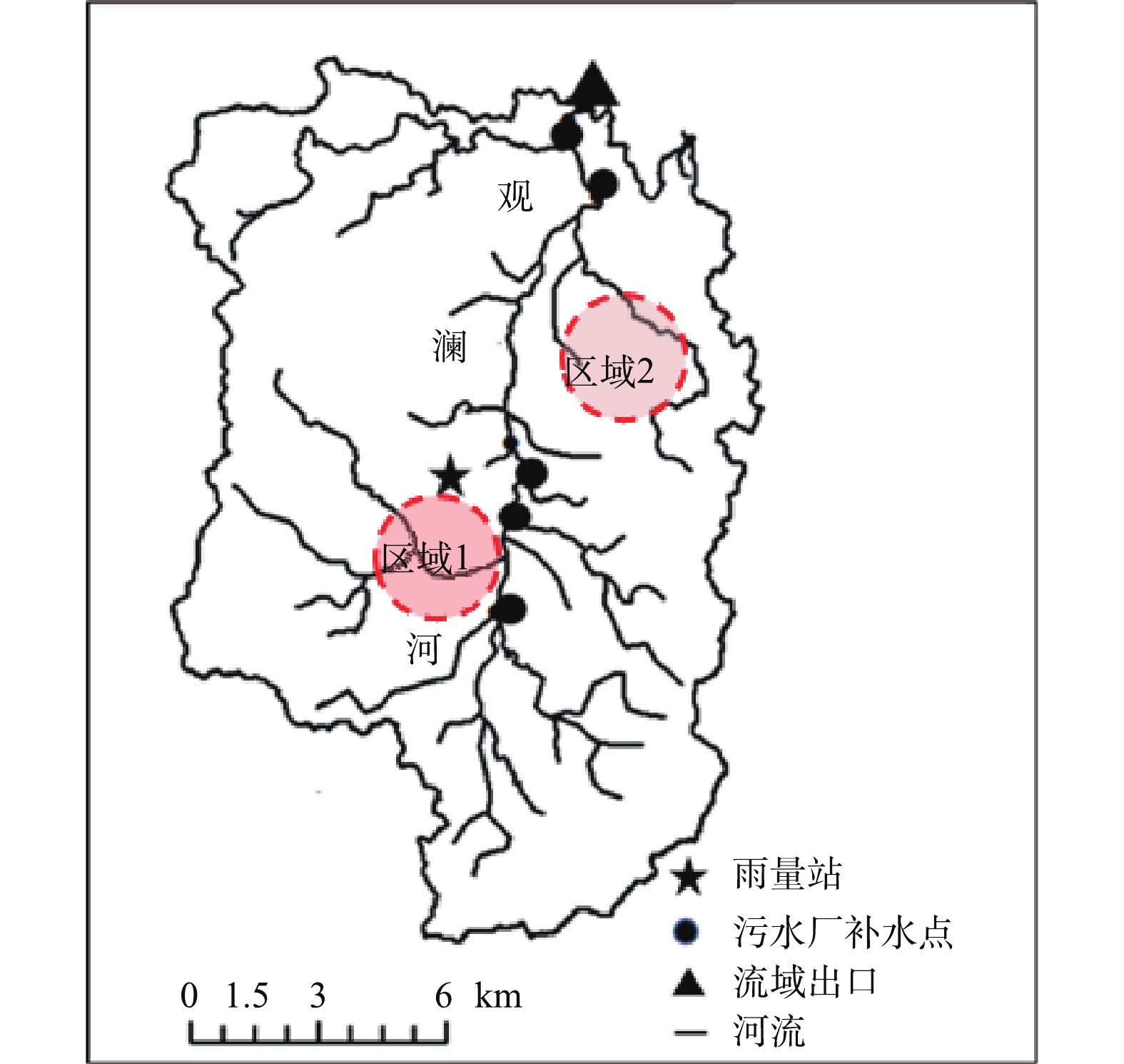
已有研究表明,地表污染物随着雨前干旱时长最终会趋于饱和。KIM[12]通过研究美国南加州高速公路的地表累积物中TSS、COD等污染物随雨前干旱时长的累积速率,发现时长为10~70 d内的TSS与COD的累积速率相比1~10 d分别下降了79%与78%。边博[13]通过对城市地表污染物累积过程的研究发现雨期干旱时长在7 d以上,地表污染物含量达到饱和。因此,本研究选择在雨前晴时长为7 d以上的无风条件下进行采样,远离清扫时间,收集一个区域内的混合样品。本研究所布设观澜河流域地表污染物累积监测点位主要集中在2个片区,采样覆盖区域面积可达22 km2,布设的采样片区内覆盖了观澜河流域主要的6类城市用地类型(图2):工业用地、高密度住宅用地(简称高密住宅)、中密度住宅用地(简称中密住宅)、商业用地、交通用地与公共管理服务用地(简称公管用地),每个片区内所布设的6类城市用地类型地表沉积物采样取样均为5个,故总的2个片区内6类城市用地类型采样区域总数为60个。为确定观澜河6类城市用地类型的DIRTMX、TNCONC、TPCONC与TNO3CONC的取值,在2018年10月—2019年10月,进行了5次地表污染物累积采样监测,采样包括降雨次数较多的雨季与降雨次数较少的旱季时期,共获得样品数300个。
-
根据施为光[14]的研究,城市降雨径流污染主要是由粒径为50~1 000 μm的细尘引起的。因此,本研究对收集到的地表累积物使用金属筛进行筛分,对于小于1 mm的颗粒物样品进行称量并记录,再反复颠簸以使不同粒径的颗粒能均匀分布,每个样品取5 g溶于1 L的去离子水中,测混合后水样的TN、硝态氮以及TP,每组样品设置3组平行样品。
本研究通过基础数据收集、现场监测分析相结合的手段来获取SWAT构建所需要的相关数据,数据类型可分为空间数据和地表观测数据2个部分,与以往研究不同的是,观澜河流域农业用地较少,城镇用地占比较大,因此,在进行数据收集时,不收集农业管理数据。SWAT模型构建所需数据及基本信息如表2所示。
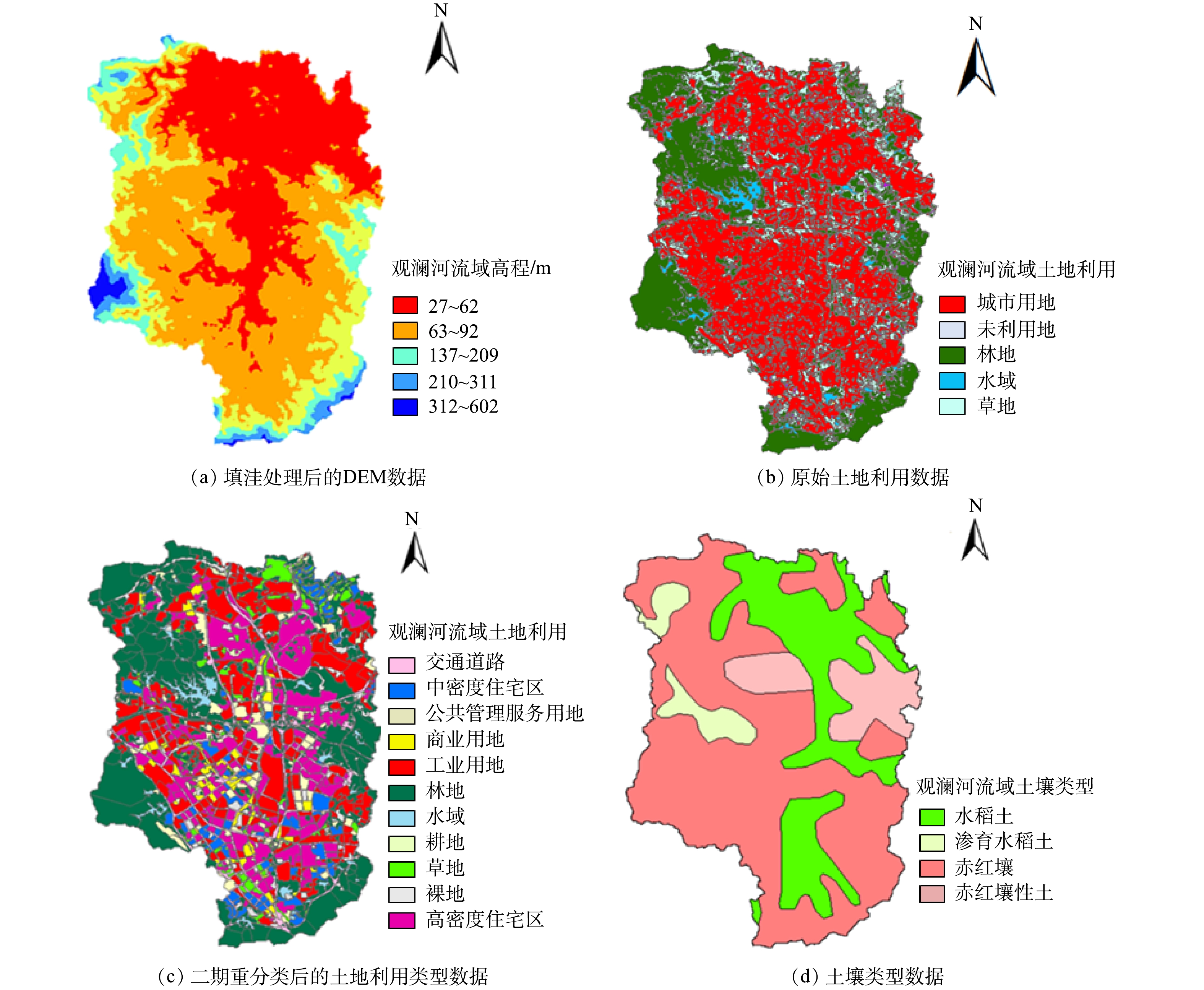
为了便于模型的构建,须对空间数据进行预处理,图3是本研究所收集到的原始空间数据以及处理后的数据。
本研究选择时空不确定性适应算法SUFI-2进行模型的校准与参数率定。该方法是一种全局敏感性分析法,取决于目标函数值与拉丁超立方生成的参数之间的多元回归系统,其表达式[15]见式(1)。
每个参数bi相对显著性用t检验来确定,各参数的敏感度用算法输出参数tstat来衡量,绝对值越大,则敏感度越高。
对于SWAT模型的模拟结果验证,本研究使用决定系数R2与纳什效率系数ENS进行综合评价,其计算方法见式(2)和式(3)。当ENS≥0.5且R2≥0.6时,模型拟合结果较好[16]。
式中:
$Q_0^t $ 为t时刻的观测值;$Q_{\rm m}^t $ 为t时刻的模拟值;${\overline {{Q_0}} }$ 为观测值的平均值;ENS取值为负无穷至1,ENS接近1,表示拟合程度好,模型可信度高。式中:
${\overline {{Q_{\rm{m}}}} }$ 为模拟值的平均值;R2的取值范围为0~1,R2值越接近于1,则模型拟合程度越高。
2.1. 研究方法
2.2. 数据处理
-
通过对观澜河流域城镇用地类型的地表累积物的采样研究,参考《SWAT 2009输入输出手册》[9]提供的相关参数范围和观澜河流域已有的研究成果,构建了观澜河流域SWAT模型城镇数据库。其中FIMP、FCIMP、CURBDEN根据现场研究确定,DIRTMX、TNCONC、TPCONC与TNO3CONC根据地表沉积物研究确定,URBCOEF、THALF、URBCN2参考《SWAT 2009输入输出手册》[9]与白凤姣等[17]关于深圳市观澜河流域CN值的校正研究确定。
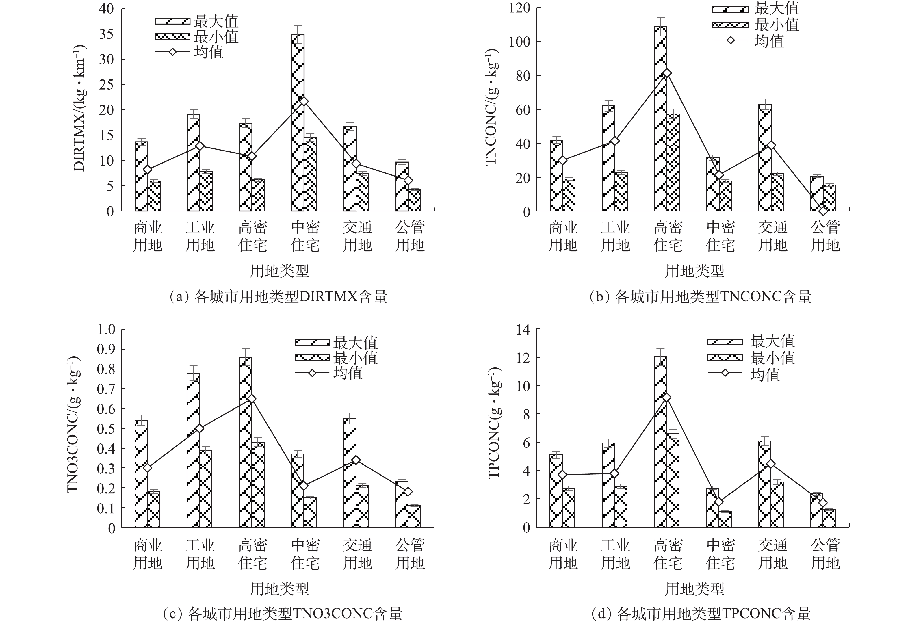
如图4所示,观澜河流域6类城市用地类型地表沉积物的DIRTMX的均值中最大值为中密度居住区21.69 kg·km−1,最小值为公管用地6.04 kg·km−1;TNCONC的均值最大值为高密度居住区81.54 g·kg−1,最小值为公管用地17.80 g·kg−1;TNO3CONC的均值最大值为高密度居住区9.17 g·kg−1,最小值为公管用地1.72 g·kg−1;TPCONC的均值最大值为高密度居住区0.65 g·kg−1,最小值为公管用地0.18 g·kg−1。建立的SWAT模型城镇数据库关键参数初始数值如表3所示,SWAT模型的城镇数据库的DIRTMX、TNCONC、TNO3CONC与TPCONC在观澜河流域的实测值与SWAT模型提供的参考值差别较大,这是由于SWAT模型城镇数据库默认的参数值是基于美国城市建设区域的相关研究,与我国城市面源污染现状差别较大。因此,在构建SWAT模型研究流域城市面源污染时,须根据当地特征修正模型SWAT模型城镇数据库参数值。
-
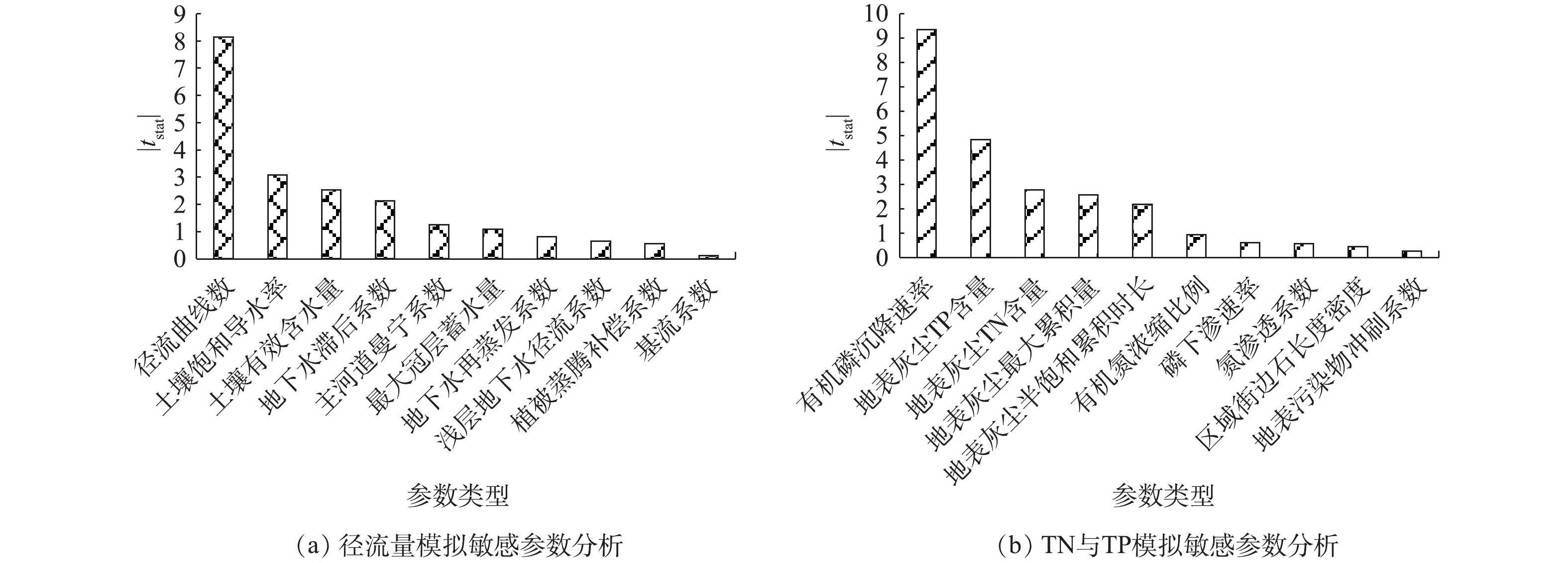
设置不同的子流域集水面积能影响SWAT模型基于观澜河流域DEM数据生成河流情况与子流域生成个数。本研究通过多次设置子流域的集水面积,发现子流域的集水面积≥300 hm2时,SWAT模型生成的观澜河流域河流情况与实际较为一致,其划分的子流域为34个。根据观澜河流域特征本研究设定的土壤类型面积阈值为15%,用地类型面积阈值为0,坡度分为3级:<2%,2%~5%与>5%,共划分为326个HRUs。通过SUIF-2对参数进行敏感性分析,确定了流域中对径流最为敏感的10个参数,以及对氮磷负荷最为敏感的10个参数,其中径流曲线数、土壤饱和导水率、土壤有效含水量与地下水滞后系数对径流量的模拟最为敏感;有效磷沉降速率、地表灰尘TP含量、地表灰尘TN含量与地表灰尘最大累积量对TN与TP的模拟最为敏感(图5)。本研究收集到观澜河流域控制断面——企坪断面2014—2018年的水量与水质数据,以此对企坪断面进行了径流量与水质的校准和验证,模拟步长设置为月,以ENS≥0.5、R2≥0.6为判断运行结束的标准。
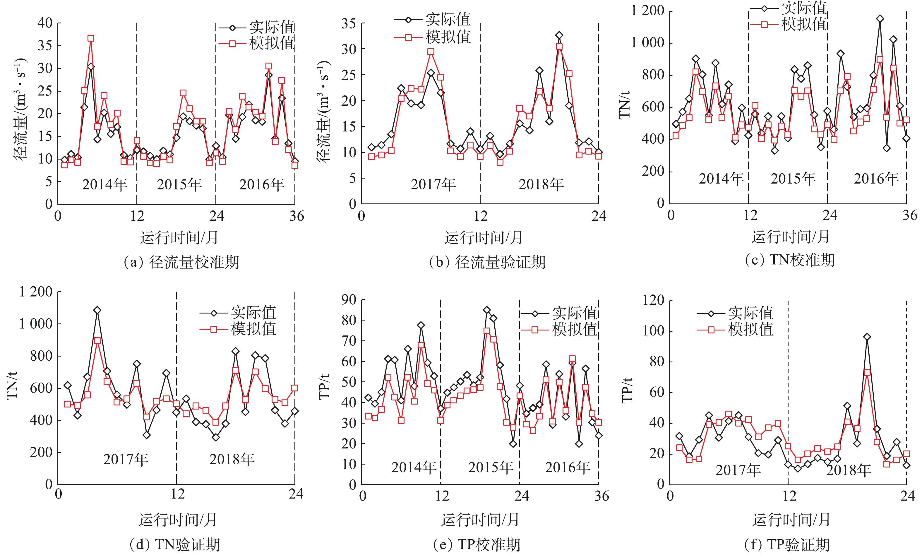
月径流量、TP与TN负荷的模拟值与实测值分析对比结果见图6。月径流量校准期的ENS为0.83,R2为0.93;验证期的ENS为0.79,R2为0.81。月TN与TP负荷的校准期的ENS分别为0.70、0.68,R2分别为0.86、0.87;月TN与TP负荷验证期的ENS分别为0.7、0.67,R2分别为0.77、0.81。由此可见,模型模拟结果可信度较高,与实际值的拟合度较好,这与城镇数据库参数修正的结论一致:DIRTMX、TNCONC、TPCONC与THALF是模型建立的关键参数。
-
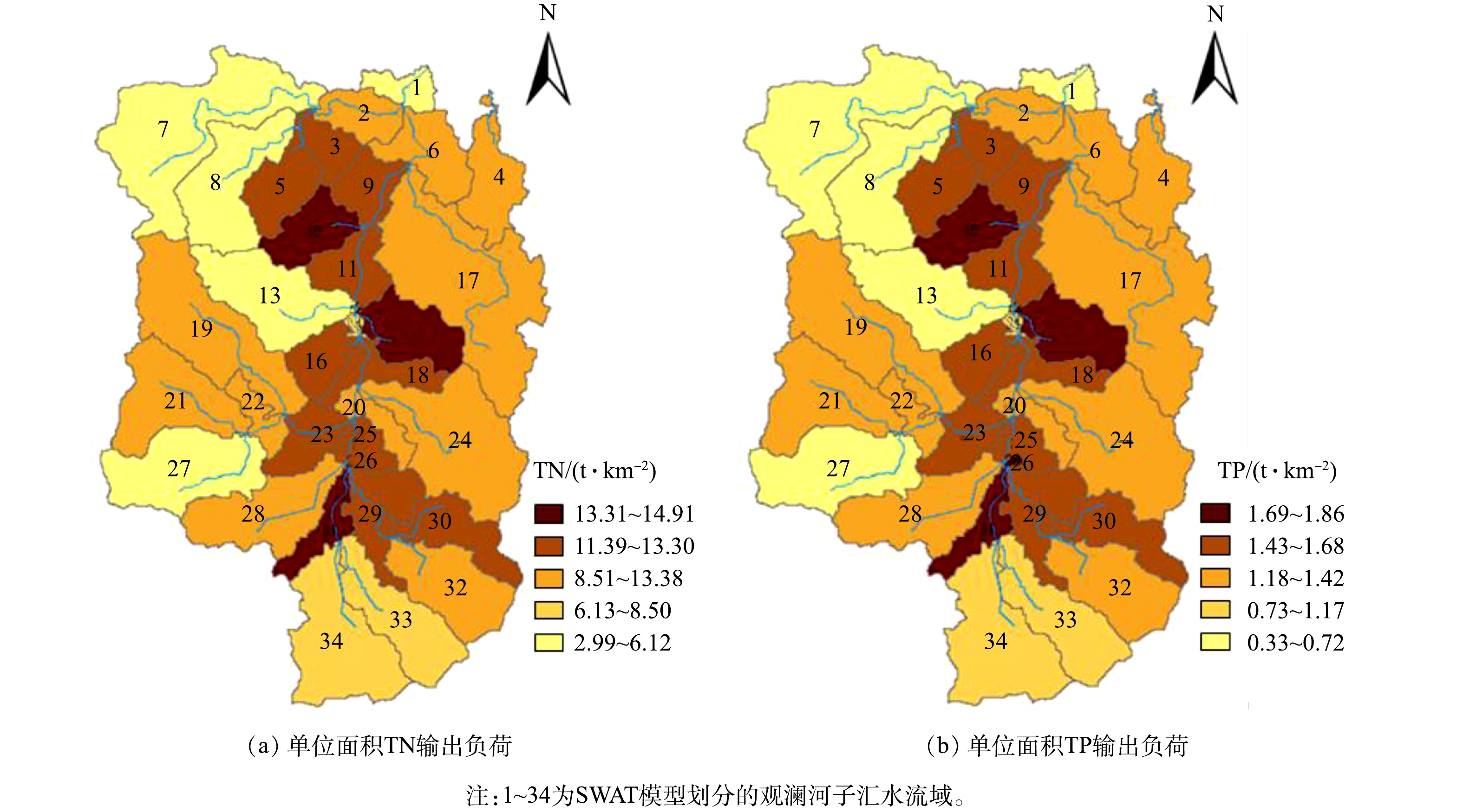
通过SWAT模型分析了2018年观澜河流域TN与TP单位面积的面源污染输出负荷的空间分布特征与各类型功能区输出的面源污染负荷对总负荷的贡献率(图7和图8)。2018年,观澜河流域TN与TP单位面积的面源污染输出负荷的空间分布特征表现一致,均在子流域为10、15、26、31号子流域内最高,分别为TN 13.31~14.91 t·km−2和TP 1.69~1.86 t·km−2。在观澜河流域6类功能区中,高密度居住区输出的TN与TP负荷贡献最高,分别为52%和49%,其次是工业用地,分别为27%和32%,公管用地最低,分别为1.5%和2.3%。
-
观澜河流域主要的输入点源为干流沿岸建设的水质净化厂尾水,通过利用收集到的2018年观澜河流域各水质净化厂尾水水量与水质日变化数据,建立SWAT模型的点源输入数据库,并基于模型分析了2018年观澜河流域城市面源污染对控制断面——企坪断面处水体TN与TP负荷的贡献情况(图9)。2018年观澜河流域4—9月的降雨径流污染产生的TN与TP负荷均高于1—3月份、10—12月,8月观澜河流域降雨径流污染最为严重,TN与TP负荷分别为2.15 t·km−2与0.24 t·km−2。
3.1. 城镇数据库构建
3.2. 模型的校准与验证
3.3. 流域城市面源污染空间分布特征
3.4. 流域城市面源污染时间分布特征
-
1) 通过对观澜河流域6类城市用地类型的地表沉积物采样监测研究与区域的现场调研,构建了SWAT模型城镇数据库并对数据库参数进行了本地化校正,发现:SWAT模型的城镇数据库的DIRTMX、TNCONC、TNO3CONC与TPCONC这4类参数在观澜河流域的实测值与SWAT模型提供的参考值差别较大,后续的相关研究应重点关注这几类城镇数据库参数的本地化校正。
2) SWAT模型参数敏感性分析表明:参数DIRTMX、TNCONC、TNALF与TPCONC对月TN与TP负荷的模拟最为敏感;构建的SWAT模型对控制断面径流量、TP与TN负荷模拟验证期的ENS分别为0.79、0.68和0.67,R2分别为0.81、0.87和0.81,模型模拟结果可信度较高,与实际值的拟合度较好。同时表明,通过对流域地表累积物的采样研究,建立并校正SWAT模型城镇数据库的方式来构建流域城市面源污染分析的SWAT模型的方法可行。
3) 利用SWAT模型分析2018年观澜河流域TN与TP的时空分布特征发现:观澜河流域TN与TP单位面积年输出负荷空间分布最高值为TN 13.31~14.91 t·km−2和TP 1.69~1.86 t·km−2;在流域6类城市用地类型中,高密度住宅区输出的TN与TP负荷贡献最高,分别为52%与49%,公共管理服务用地最低,分别为1.5%与2.3%;2018年观澜河流域4—9月的降雨径流污染产生的TN与TP负荷均高于1—3月、10—12月,8月观澜河流域降雨径流污染最为严重,TN与TP负荷分别为:2.15 t·km−2和0.24 t·km−2。


 下载:
下载:
