重金属是常见的环境污染物,因其强生物毒性、难降解性及易生物富集等而备受关注[1]。其来源广泛,可通过生活污水、工农业废水排放或地表径流等途径进入水体系统。绝大部分重金属会被悬浮颗粒物吸附或结合而最终富集在沉积物中,同时在某些条件下(比如风浪潮汐、挖掘采沙、船运和底栖生物活动等)沉积物中的重金属又可释放到水体中,造成二次污染。因此,对既是河流重金属“汇”,又是河流重金属“源”[2]的沉积物中重金属分布特征研究可以判断一定时期内其区域污染程度。自20世纪70年代以来,研究者对自然水体及其表层沉积物中的重金属污染开展了大量研究,发现不同地区不同水体重金属污染程度各有不同[3-5]。
海河水系包括永定河、蓟运河、大清河、漳卫南运河、潮白河、北运河、子牙河和黑龙港运东地区诸河等[6],流域总面积31.8万km2,涵盖北京、天津和河北等8个省市。由于海河流域为我国政治文化中心所在地,在国民经济中占有举足轻重的地位,很多学者对其水体或沉积物中重金属污染进行了调研,但研究工作大多是对个别或少数条河流设置采样点进行的。目前,对海河水系重金属的大尺度研究较少,整体上海河流域水中重金属污染特征及风险状况仍然不清楚。
文献计量学是通过对文献标题、摘要、关键词和全文进行分析,运用统计学等数学工具来描述研究领域趋势或特征的研究方法,可在较大的时间尺度和空间跨度上对某一问题等进行系统研究,已被用于环境中重金属的环境污染特征研究[7]。本研究借助该手段以整个海河流域作为研究区域,系统分析了近20年海河水系水体和沉积物中几种重金属的污染特征,并利用内梅罗综合污染指数法和潜在生态风险指数法进行了污染水平和生态风险评价,以期为后续该流域重金属的污染控制提供参考。
1 材料与方法(Materials and methods)
1.1 数据来源
本研究中海河水系重金属浓度数据通过以下文献检索而获得。
1.1.1 文献检索策略
检索中国知网(CNKI)和Web of Science两大综合性文献数据库,文献范围限定为2000—2021年。中文检索关键词为“重金属/镉/铬/铜/锌/铅/砷/镍”,主题词“海河/永定河/蓟运河/大清河/北运河/潮白河/子牙河/漳卫南运河/黑龙港”;英文检索关键词为“Heavy metals/Cadmium/Chromium/Copper/Zinc/Lead/Arsenic/Nickel”和“China”,主题词“Haihe River/Yongding River/Jiyun River/Daqing River/Beiyun River/Ziya River/Chaobai River/Zhangwei South River/ Heilonggang”。检索式使用布尔位置运算符(“AND”、“OR”)。
1.1.2 文献筛选标准
纳入标准:①样品为河水或河流表层沉积物;②采样地点明确;③重金属检测方法科学可信;④统计参数至少包括样本量、均值和标准差;或样本量、中位数和最大/最小值。
排除标准:①重复性文献;②综述类文献;③实验室模拟试验样品;④统计参数不全。
根据上述策略,在数据库中检索到相关文献385篇,经筛选最终纳入49篇,具体流程如图1所示。
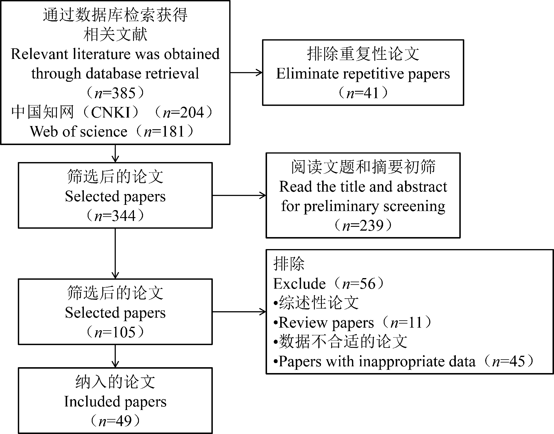
图1 文献筛选流程
Fig. 1 Literature screening process
1.2 数据提取与统计处理
从纳入文献中提取数据包括发表时间、采样地点、样品类型、样本量、检测方法、检出限和浓度数据。通过Excel 2019预处理数据,使用SPSS26软件进行重金属浓度数据统计处理。其中,每篇文献报告的均值和标准差若可直接从文献中读取的就直接读取,不能读取的则根据样本量、中位数、最小值和最大值等统计值间接计算。然后根据样本量、均值和标准差统计整体的均值(加权平均值)、标准差和均值的中位数[7]。
1.3 风险评价
为确定海河水系水中和表层沉积物中重金属污染程度,分别采用内梅罗综合污染指数法和潜在生态风险指数法进行污染评价。
1.3.1 内梅罗综合污染指数法
内梅罗综合污染指数法能够反映环境中重金属污染现状及各种重金属对复合污染的不同贡献,并甄别主要污染物,是水体重金属污染评价的常用方法之一[8]。计算公式分别为:
单因子污染指数![]()
(1)
内梅罗综合污染指数![]()
(2)
式中:Wi为重金属i检测浓度;Bi为重金属i相应的环境标准值;max(Pi)为重金属单因子污染指数最大值;ave(Pi)为各重金属单因子污染指数平均值。本研究选用《地表水环境质量标准》(GB 3838—2002)V类水域标准限值作为环境标准值[9],根据内梅罗污染指数法评价分为5个等级,其等级分类标准可参考陈明等[10]的研究。
1.3.2 潜在生态风险指数法
潜在生态风险指数法综合考虑了沉积物中各种重金属的浓度水平和毒性效应,是评价沉积物重金属生态风险的最常用方法[11-12]。其计算公式为:
(3)
式中:RI为潜在生态风险指数;Ei为重金属i的潜在生态风险系数;Ti为重金属i的毒性系数,Si为重金属i的污染参数;Ci为重金属i的检测浓度;Di为重金属i的地球化学背景值。
由于本研究中水系分布范围较大,故Di值采用中国水系沉积物背景值[13],其中,镉(Cd)、铬(Cr)、铜(Cu)、锌(Zn)、铅(Pb)、砷(As)和镍(Ni)的Di分别为0.18、61、23、71、27、12和26 mg·kg-1。Ti值采用徐争启等[14]的推荐值,即TCd=30,TAs=10,TCr=2,TZn=1,TCu=TPb=TNi=5。根据评价的重金属种类,参考周旭[15]的方法,确定本研究中潜在生态风险程度的RI分级标准为:轻微(RI<66)、中等(66≤RI<132)、强(132≤RI<264)、很强(264≤RI<528)和极强(RI≥528)。
2 结果与讨论(Results and discussion)
2.1 海河水系水中重金属含量分布特征
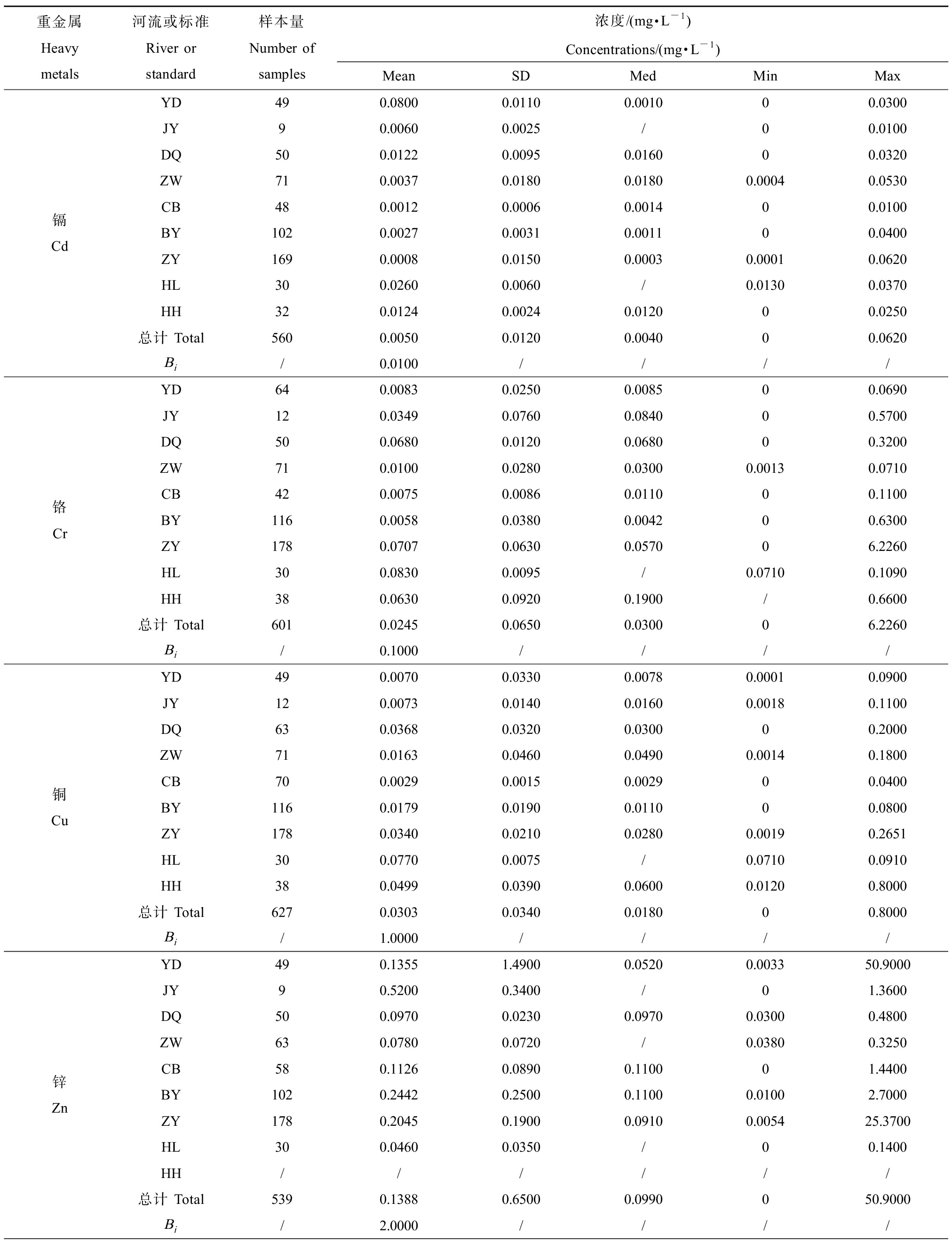
海河水系6种重金属Cd、Cr、Cu、Zn、Pb和As浓度统计结果如表1所示,其平均浓度顺序为:Zn(0.1388 mg·L-1)>Cu(0.0303 mg·L-1)>Pb(0.0293 mg·L-1)>Cr(0.0245 mg·L-1)>Cd(0.0050 mg·L-1)=As(0.0050 mg·L-1)。与《地表水环境质量标准》(GB 3838—2002)Ⅴ类水域标准限值来看,总体上海河水系6种重金属的平均浓度虽然未超标,但部分河流存在超标现象。如大清河、海河干流和黑龙港的Cd,其平均浓度均超过Ⅴ类水质限值,且Cd在各个河流的部分检测点位均有超出Ⅴ类水质限值的现象,故相对其他重金属来说污染可能严重一些。需要特别注意的是Cr在上述河流中报道的最高浓度是Ⅴ类水质限值的62.26倍,Zn的最高浓度则达到了25.45倍。此外,Cr在蓟运河、北运河和子牙河的部分检测点位超出了Ⅴ类水质限值,而其他几种重金属超标率较低,Cu甚至在所有检测点位均没有超标。表1的统计数据还表明重金属在各个河流的浓度分布波动较大,同时在不同河流的空间差异也较明显,可能是受到不同区域工农业污染排放的影响。
表1 海河水系水体重金属浓度水平
Table 1 Concentrations of heavy metals in river water of Haihe Basin
重金属Heavy metals河流或标准River or standard样本量Number of samples浓度/(mg·L-1) Concentrations/(mg·L-1)MeanSDMedMinMax镉CdYD490.08000.01100.001000.0300JY90.00600.0025/00.0100DQ500.01220.00950.016000.0320ZW710.00370.01800.01800.00040.0530CB480.00120.00060.001400.0100BY1020.00270.00310.001100.0400ZY1690.00080.01500.00030.00010.0620HL300.02600.0060/0.01300.0370HH320.01240.00240.012000.0250总计 Total5600.00500.01200.004000.0620Bi/0.0100////铬CrYD640.00830.02500.008500.0690JY120.03490.07600.084000.5700DQ500.06800.01200.068000.3200ZW710.01000.02800.03000.00130.0710CB420.00750.00860.011000.1100BY1160.00580.03800.004200.6300ZY1780.07070.06300.057006.2260HL300.08300.0095/0.07100.1090HH380.06300.09200.1900/0.6600总计 Total6010.02450.06500.030006.2260Bi/0.1000////铜CuYD490.00700.03300.00780.00010.0900JY120.00730.01400.01600.00180.1100DQ630.03680.03200.030000.2000ZW710.01630.04600.04900.00140.1800CB700.00290.00150.002900.0400BY1160.01790.01900.011000.0800ZY1780.03400.02100.02800.00190.2651HL300.07700.0075/0.07100.0910HH380.04990.03900.06000.01200.8000总计 Total6270.03030.03400.018000.8000Bi/1.0000////锌ZnYD490.13551.49000.05200.003350.9000JY90.52000.3400/01.3600DQ500.09700.02300.09700.03000.4800ZW630.07800.0720/0.03800.3250CB580.11260.08900.110001.4400BY1020.24420.25000.11000.01002.7000ZY1780.20450.19000.09100.005425.3700HL300.04600.0350/00.1400HH//////总计 Total5390.13880.65000.0990050.9000Bi/2.0000////
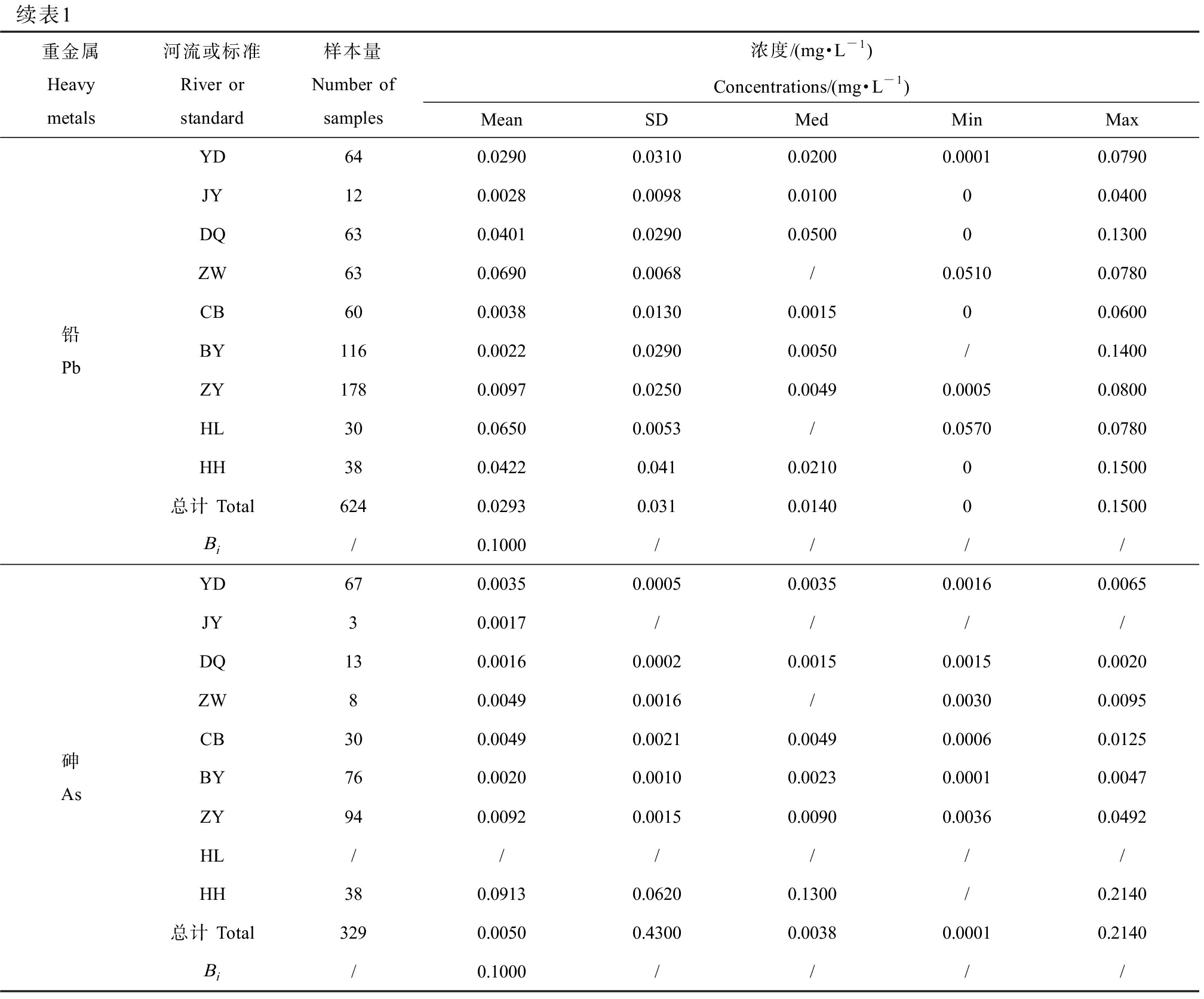
续表1重金属Heavy metals河流或标准River or standard样本量Number of samples浓度/(mg·L-1) Concentrations/(mg·L-1)MeanSDMedMinMax铅PbYD640.02900.03100.02000.00010.0790JY120.00280.00980.010000.0400DQ630.04010.02900.050000.1300ZW630.06900.0068/0.05100.0780CB600.00380.01300.001500.0600BY1160.00220.02900.0050/0.1400ZY1780.00970.02500.00490.00050.0800HL300.06500.0053/0.05700.0780HH380.04220.0410.021000.1500总计 Total6240.02930.0310.014000.1500Bi/0.1000////砷AsYD670.00350.00050.00350.00160.0065JY30.0017////DQ130.00160.00020.00150.00150.0020ZW80.00490.0016/0.00300.0095CB300.00490.00210.00490.00060.0125BY760.00200.00100.00230.00010.0047ZY940.00920.00150.00900.00360.0492HL//////HH380.09130.06200.1300/0.2140总计 Total3290.00500.43000.00380.00010.2140Bi/0.1000////
注:YD为永定河;JY为蓟运河;DQ为大清河;ZW为漳卫南运河;CB为潮白河;BY为北运河;ZY为子牙河;HL为黑龙港;HH为海河干流;Bi为《地表水环境质量标准》(GB 3838—2002)Ⅴ类环境标准值;Mean为平均值;SD为标准偏差;Med为中位数;Min为最小值;Max为最大值;“0”为未检出;“/”为未能提取数据。
Note: YD means Yongding River; JY means Jiyun River; DQ means Daqing River; ZW means Zhangweinan River; CB means Chaobai River; BY means Beiyun River; ZY means Ziya River; HL means Heilonggang River; HH means Haihe River mainstream; Bi means Level Ⅴ values in the Chinese environmental quality standards for surface water (GB 3838—2002); Mean means mean value; SD means standard deviation; Med means median value; Min means minimum value; Max means maximum value; “0” means below detection limit; “/” means not available.
2.2 表层沉积物重金属含量分布特征
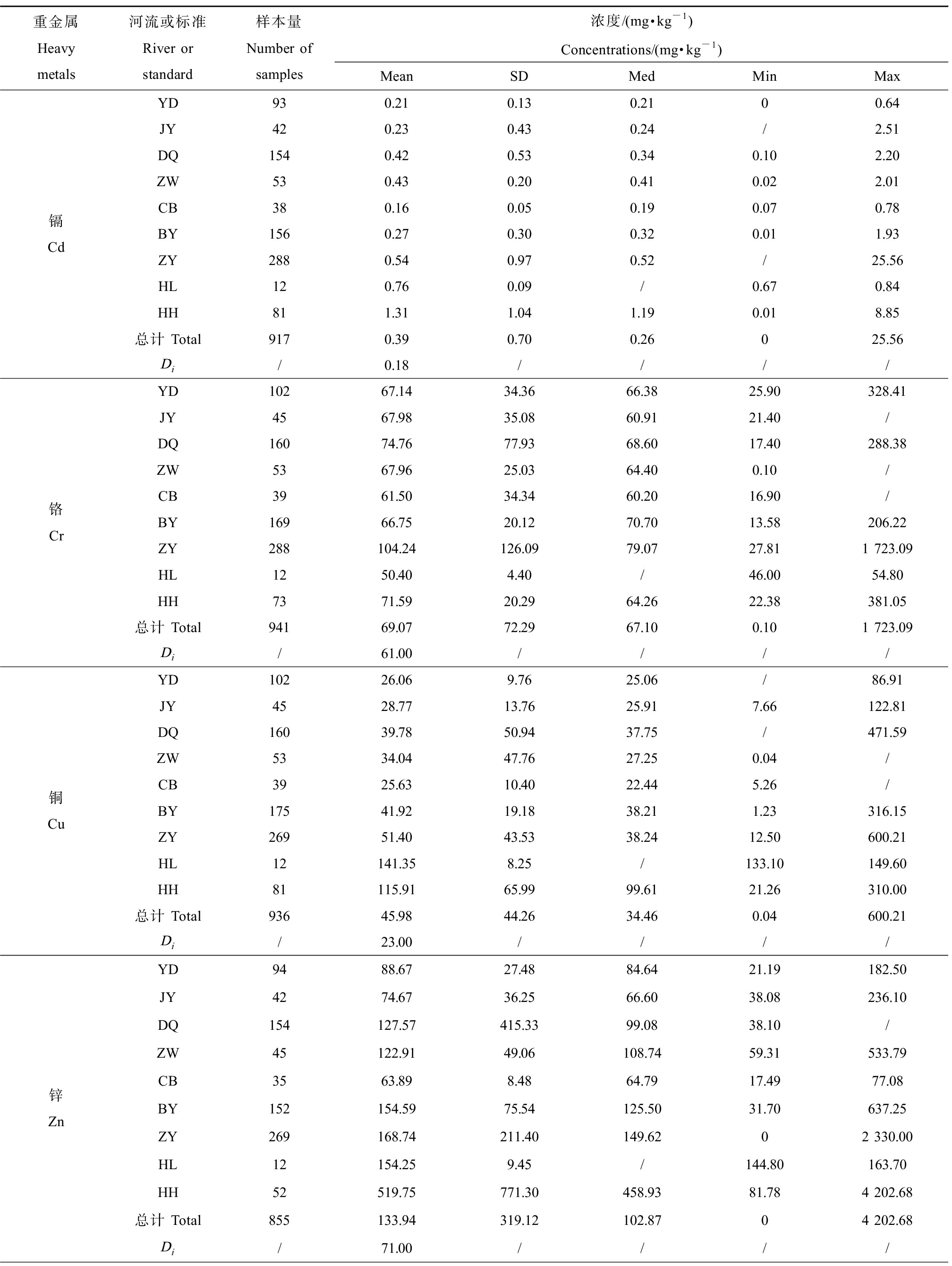
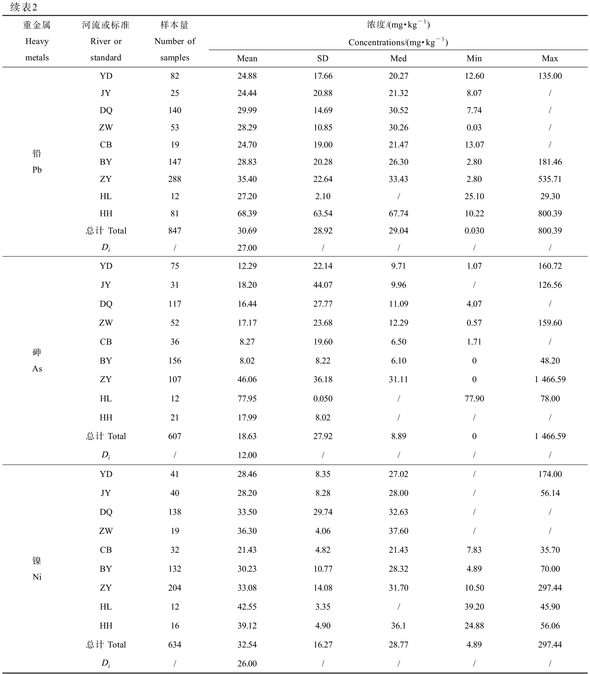
海河水系整体上表层沉积物重金属含量平均浓度由高到低依次为Zn>Cr>Cu>Ni>Pb>As>Cd,浓度范围为0.39~133.94 mg·kg-1(表2)。各种重金属均高于中国水系沉积物背景值,为1.13倍~2.17倍。从具体河流沉积物来看,除了黑龙港的Cr、北运河的As、蓟运河和永定河的Pb、潮白河的Cd、Pb、Zn、As和Ni其浓度低于中国水系沉积物背景值外,其他的均高于背景值,特别是海河干流,其沉积物中Zn、Cd和Pb浓度分别为相对应背景值的7.32倍、7.28倍和2.53倍。分析原因可能与海河流经人口稠密、工业发达的天津市中心城区和塘沽区有关[16]。子牙河沉积物Cr含量最高,为背景值1.71倍,可能与其流经地区分布着大量的工业企业有关[17]。黑龙港沉积物Cu、As和Ni含量最高,分别是背景值的6.15倍、6.05倍和1.64倍,原因可能与其上游石化、冶金等工业排放废水有关[18]。与国内其他流域沉积物重金属相比,海河水系表层沉积物各重金属平均浓度均低于珠江[19],但均高于黄河[20]和辽河[21];除Cr之外,亦均高于长江的水平[22]。同样由表2可知,各重金属在不同河流的浓度水平和空间差异性存在较大不同,可能与不同区域的人类活动密切相关。
表2 海河水系沉积物重金属浓度水平
Table 2 Concentrations of heavy metals in sediments of Haihe Basin
重金属Heavy metals河流或标准River or standard样本量Number of samples浓度/(mg·kg-1)Concentrations/(mg·kg-1)MeanSDMedMinMax镉CdYD930.210.130.2100.64JY420.230.430.24/2.51DQ1540.420.530.340.102.20ZW530.430.200.410.022.01CB380.160.050.190.070.78BY1560.270.300.320.011.93ZY2880.540.970.52/25.56HL120.760.09/0.670.84HH811.311.041.190.018.85总计 Total9170.390.700.26025.56Di/0.18////铬CrYD10267.1434.3666.3825.90328.41JY4567.9835.0860.9121.40/DQ16074.7677.9368.6017.40288.38ZW5367.9625.0364.400.10/CB3961.5034.3460.2016.90/BY16966.7520.1270.7013.58206.22ZY288104.24126.0979.0727.811 723.09HL1250.404.40/46.0054.80HH7371.5920.2964.2622.38381.05总计 Total94169.0772.2967.100.101 723.09Di/61.00////铜CuYD10226.069.7625.06/86.91JY4528.7713.7625.917.66122.81DQ16039.7850.9437.75/471.59ZW5334.0447.7627.250.04/CB3925.6310.4022.445.26/BY17541.9219.1838.211.23316.15ZY26951.4043.5338.2412.50600.21HL12141.358.25/133.10149.60HH81115.9165.9999.6121.26310.00总计 Total93645.9844.2634.460.04600.21Di/23.00////锌ZnYD9488.6727.4884.6421.19182.50JY4274.6736.2566.6038.08236.10DQ154127.57415.3399.0838.10/ZW45122.9149.06108.7459.31533.79CB3563.898.4864.7917.4977.08BY152154.5975.54125.5031.70637.25ZY269168.74211.40149.6202 330.00HL12154.259.45/144.80163.70HH52519.75771.30458.9381.784 202.68总计 Total855133.94319.12102.8704 202.68Di/71.00////
续表2重金属Heavy metals河流或标准River or standard样本量Number of samples浓度/(mg·kg-1)Concentrations/(mg·kg-1)MeanSDMedMinMax铅PbYD8224.8817.6620.2712.60135.00JY2524.4420.8821.328.07/DQ14029.9914.6930.527.74/ZW5328.2910.8530.260.03/CB1924.7019.0021.4713.07/BY14728.8320.2826.302.80181.46ZY28835.4022.6433.432.80535.71HL1227.202.10/25.1029.30HH8168.3963.5467.7410.22800.39总计 Total84730.6928.9229.040.030800.39Di/27.00////砷AsYD7512.2922.149.711.07160.72JY3118.2044.079.96/126.56DQ11716.4427.7711.094.07/ZW5217.1723.6812.290.57159.60CB368.2719.606.501.71/BY1568.028.226.10048.20ZY10746.0636.1831.1101 466.59HL1277.950.050/77.9078.00HH2117.998.02///总计Total60718.6327.928.8901 466.59Di/12.00////镍NiYD4128.468.3527.02/174.00JY4028.208.2828.00/56.14DQ13833.5029.7432.63//ZW1936.304.0637.60//CB3221.434.8221.437.8335.70BY13230.2310.7728.324.8970.00ZY20433.0814.0831.7010.50297.44HL1242.553.35/39.2045.90HH1639.124.9036.124.8856.06总计Total63432.5416.2728.774.89297.44Di/26.00////
注:Di为中国水系沉积物背景值;其他代号同表1。
Note: Di means background values of stream sediment in China; other symbols are the same as those in Table 1.
2.3 海河水系水中重金属污染评价
使用内梅罗综合污染指数法对海河水系各河水中重金属污染进行评价。由图2可知,各河水体中重金属污染程度(Pn)排序为:黑龙港(1.93)>子牙河(0.93)>大清河(0.83)>永定河(0.60)>海河干流(0.52)>漳卫南运河(0.32)>蓟运河(0.26)>北运河(0.10)>潮白河(0.08)。总体来看,黑龙港重金属污染呈轻度水平,大清河和子牙河为警戒水平,其他河流则处于安全水平。黑龙港轻度污染主要是Cd导致的,可能与该研究区域的采矿、皮革工业活动和农业施肥有关[9]。

图2 海河水系水中重金属内梅罗综合污染指数评价结果空间分布
注:YD为永定河;JY为蓟运河;DQ为大清河;ZW为漳卫南运河;CB为潮白河;BY为北运河;ZY为子牙河;HL为黑龙港;HH为海河干流。
Fig. 2 Distribution of Nemerow integrated pollution index for heavy metals in water from Haihe Basin
Note: YD means Yongding River; JY means Jiyun River; DQ means Daqing River; ZW means Zhangweinan River; CB means Chaobai River;
BY means Beiyun River; ZY means Ziya River; HL means Heilonggang River; HH means Haihe River mainstream.
2.4 海河水系沉积物重金属潜在生态风险评价
各河流沉积物重金属潜在生态风险程度(以RI值表征)为:海河干流(332)>黑龙港(239)>子牙河(164)>漳卫南运河(110)>大清河(108)>北运河(91)>蓟运河(76)>永定河(64)>潮白河(48)。海河干流有很强生态风险,黑龙港和子牙河均达到强生态风险,漳卫南运河、大清河、北运河和蓟运河均处于中等风险等级,永定河和潮白河都是轻微生态风险(图3)。造成海河干流很强生态风险可能与海河流经人口稠密、工业发达的天津市中心城区和塘沽区有关,工业企业排放含有重金属的废水,进入到河流等水体并在沉积物中积累[23]。黑龙港处于强生态风险同样是该地区人类生产和生活的排放造成的[18]。从贡献率来看,Cd对海河水系沉积物重金属潜在生态风险起了主导作用(图4),是需要重点关注的对象。
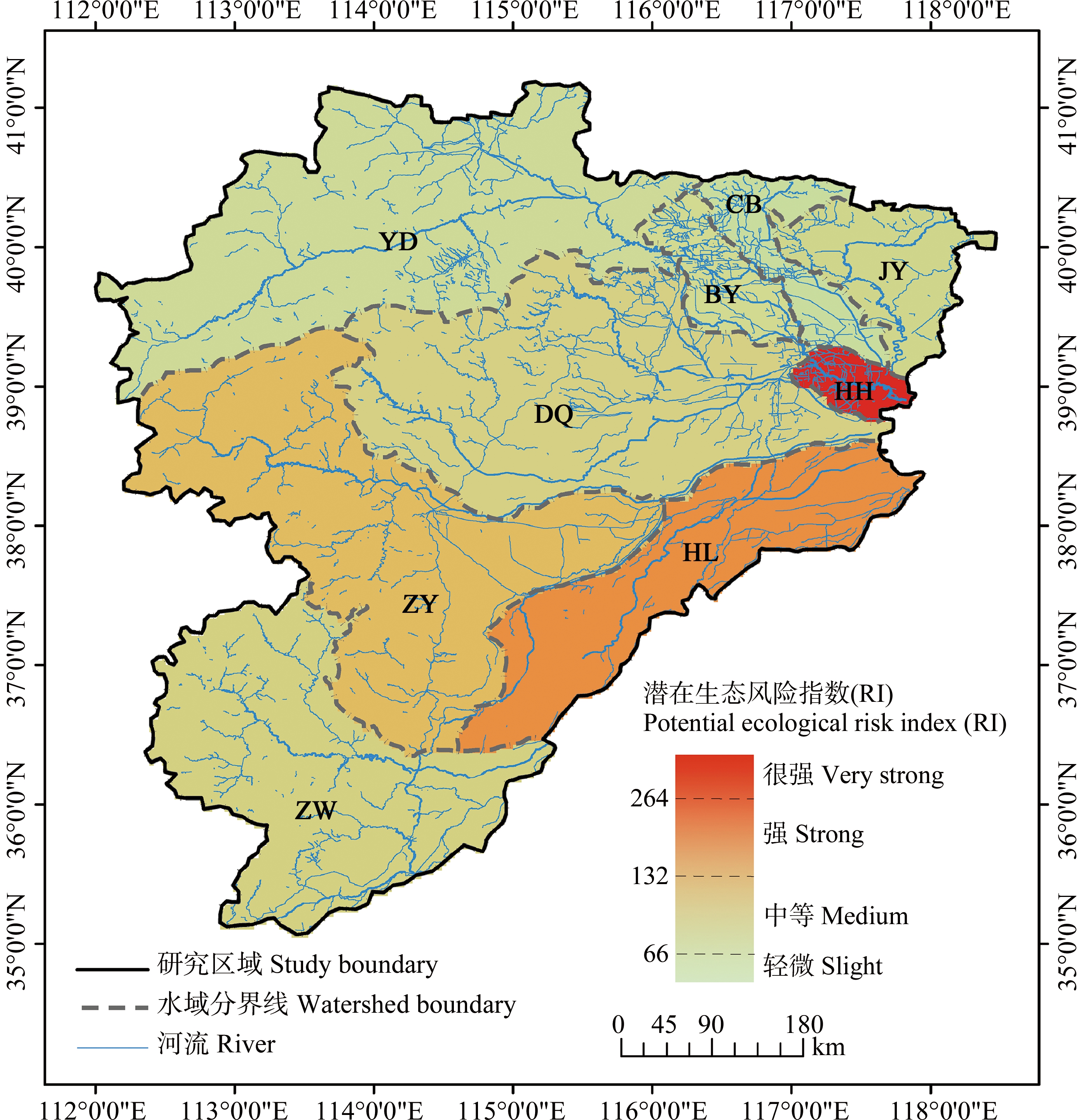
图3 海河水系沉积物重金属潜在生态风险空间分布
注:YD为永定河;JY为蓟运河;DQ为大清河;ZW为漳卫南运河;CB为潮白河;BY为北运河;ZY为子牙河;HL为黑龙港;HH为海河干流。
Fig. 3 Distribution of potential ecological risk of heavy metals in sediments from Haihe Basin
Note: YD means Yongding River; JY means Jiyun River; DQ means Daqing River; ZW means Zhangweinan River; CB means Chaobai River;
BY means Beiyun River; ZY means Ziya River; HL means Heilonggang River; HH means Haihe River mainstream.
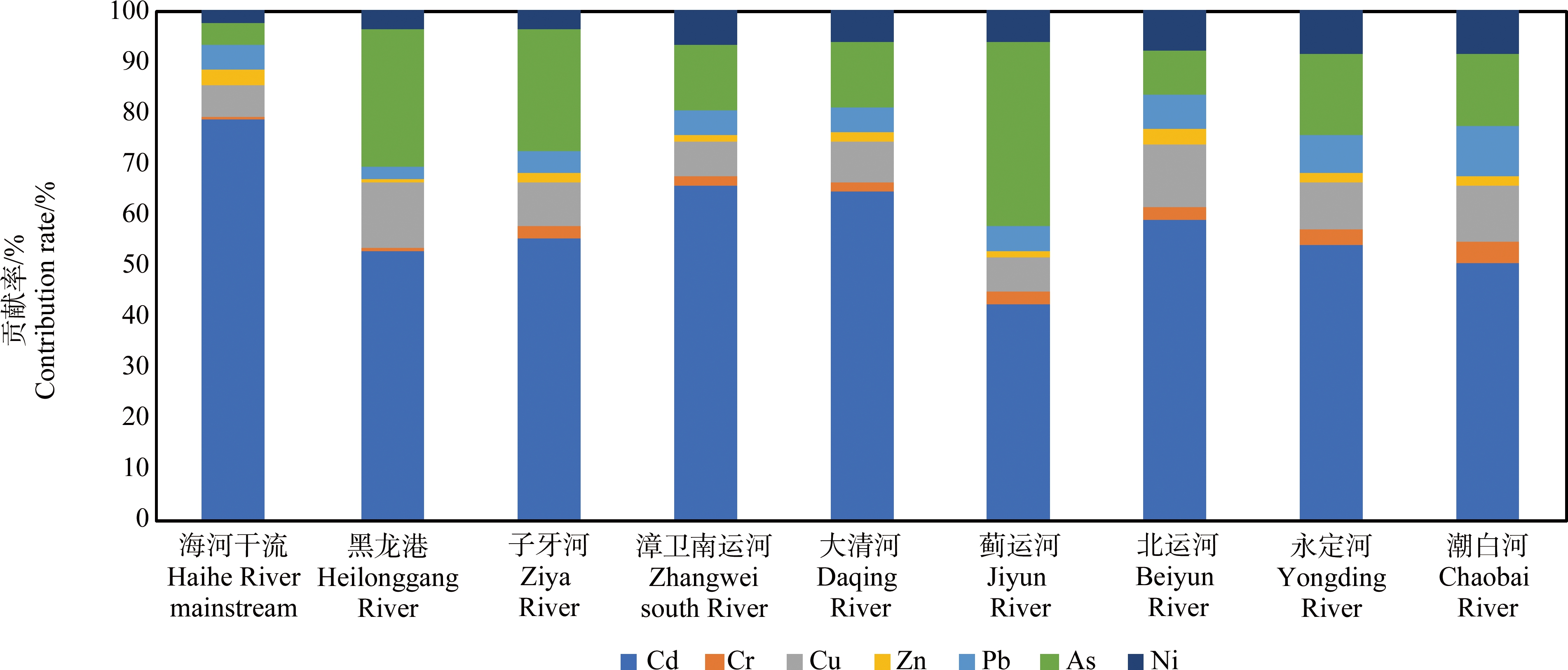
图4 海河水系沉积物潜在生态风险各重金属贡献率
Fig. 4 Contribution rate of heavy metals to potential ecological risk of sediments in Haihe Basin
本研究表明,海河水系水体中6种重金属平均含量由高到低依次为Zn>Cu>Pb>Cr>Cd=As,均未超出Ⅴ类水质限值,但存在部分采样点位重金属超标现象。水体沉积物中各重金属与中国水系沉积物背景值相比均超标,超标倍数依次为Cd(2.17)>Cu(2.00)>Zn(1.89)>As(1.55)>Ni(1.25)>Pb(1.14)>Cr(1.13)。内梅罗综合污染指数评价表明水体中重金属污染黑龙港为轻度水平,其他河流污染处于警戒或安全水平。水系沉积物中重金属潜在生态风险最高的为海河干流,其次为黑龙港和子牙河,其他河流为中等或轻微的风险范畴。Cd是潜在生态风险最大的贡献者,是风险防控中需要特别关注的对象。
[1] 龚杰, 孙紫童, 冯璐, 等. 武汉市东西湖区主要湖泊表层沉积物重金属污染特征与生态风险评价[J]. 地质科技通报, 2021, 40(3): 204-210
Gong J, Sun Z T, Feng L, et al. Pollution characteristics and ecological risk assessment of heavy metals in surface sediments of main lakes in Dongxihu District, Wuhan [J]. Bulletin of Geological Science and Technology, 2021, 40(3): 204-210 (in Chinese)
[2] 俞慎, 历红波. 沉积物再悬浮-重金属释放机制研究进展[J]. 生态环境学报, 2010, 19(7): 1724-1731
Yu S, Li H B. Perspectives on the release of heavy metals via sediment resuspension [J]. Ecology and Environmental Sciences, 2010, 19(7): 1724-1731 (in Chinese)
[3] Singh H, Pandey R, Singh S K, et al. Assessment of heavy metal contamination in the sediment of the River Ghaghara, a major tributary of the River Ganga in Northern India [J]. Applied Water Science, 2017, 7(7): 4133-4149
[4] 高煜, 王国兰, 金梓函, 等. 千河下游水体-沉积物重金属空间分布、风险及影响因素[J]. 环境科学, 2021, 42(11): 5333-5345
Gao Y, Wang G L, Jin Z H, et al. Spatial distribution, risk, and influencing factors of river water-sediment heavy metals in the lower reaches of the Qianhe River [J]. Environmental Science, 2021, 42(11): 5333-5345 (in Chinese)
[5] Xiong J H, Zhao T Y, Cheng H, et al. The assessment on the heavy metal pollution and health risks in the Liujiang River under the Xijiang River region [J]. Desalination and Water Treatment, 2019, 149: 315-322
[6] 《中国河湖大典》编纂委员会. 中国河湖大典. 海河卷[M]. 北京: 中国水利水电出版社, 2010: 1-9
Editorial Committee of Encyclopedia of Rivers and Lakes in China. Encyclopedia of Rivers and Lakes in China: Section of Haihe Basin [M]. Beijing: China Water Conservancy and Hydropower Press, 2010: 1-9 (in Chinese)
[7] Hu B F, Shao S, Ni H, et al. Current status, spatial features, health risks, and potential driving factors of soil heavy metal pollution in China at province level [J]. Environmental Pollution, 2020, 266(Pt 3): 114961
[8] 贾旭威, 王晨, 曾祥英, 等. 三峡沉积物中重金属污染累积及潜在生态风险评估[J]. 地球化学, 2014, 43(2): 174-179
Jia X W, Wang C, Zeng X Y, et al. The occurrence, accumulation and preliminary risk assessment of heavy metals in sediments from the main tributaries in the Three Gorges Reservoir [J]. Geochimica, 2014, 43(2): 174-179 (in Chinese)
[9] Tang W Z, Zhao Y, Wang C, et al. Heavy metal contamination of overlying waters and bed sediments of Haihe Basin in China [J]. Ecotoxicology and Environmental Safety, 2013, 98: 317-323
[10] 陈明, 李凤果, 陶美霞, 等. 赣南典型矿区河流上覆水与表层沉积物重金属分布特征及风险评价[J]. 环境化学, 2019, 38(7): 1461-1469
Chen M, Li F G, Tao M X, et al. Distribution characteristics and risk assessment of heavy metals in overlying water and surface sediments in rivers in typical mining areas of southern Jiangxi Province [J]. Environmental Chemistry, 2019, 38(7): 1461-1469 (in Chinese)
[11] Maanan M, Saddik M, Maanan M, et al. Environmental and ecological risk assessment of heavy metals in sediments of Nador lagoon, Morocco [J]. Ecological Indicators, 2015, 48: 616-626
[12] Ke X, Gui S F, Huang H, et al. Ecological risk assessment and source identification for heavy metals in surface sediment from the Liaohe River protected area, China [J]. Chemosphere, 2017, 175: 473-481
[13] 迟清华, 鄢明才. 应用地球化学元素丰度数据手册[M]. 北京: 地质出版社, 2007: 92-93
[14] 徐争启, 倪师军, 庹先国, 等. 潜在生态危害指数法评价中重金属毒性系数计算[J]. 环境科学与技术, 2008, 31(2): 112-115
Xu Z Q, Ni S J, Tuo X G, et al. Calculation of heavy metals’ toxicity coefficient in the evaluation of potential ecological risk index [J]. Environmental Science & Technology, 2008, 31(2): 112-115 (in Chinese)
[15] 周旭. 龙口市土壤重金属来源、空间分布及生态风险评价[D]. 济南: 山东师范大学, 2019: 36-37
Zhou X. Source, spatial distribution and ecological risk assessment of heavy metals in soil of Longkou City [D]. Jinan: Shandong Normal University, 2019: 36-37 (in Chinese)
[16] 叶飞, 周其文, 刘书田, 等. 天津市主要河流水质调查与评价[J]. 环境卫生工程, 2009, 17(6): 9-11
Ye F, Zhou Q W, Liu S T, et al. Investigation and evaluation of water quality for main rivers in Tianjin [J]. Environmental Sanitation Engineering, 2009, 17(6): 9-11 (in Chinese)
[17] 吴二威. 海河支流重金属污染特征及Hg2+对水生藻类的毒性研究[D]. 石河子: 石河子大学, 2014: 22-36
Wu E W. Characteristics of heavy metals pollution and toxicity of Hg2+ to the aquatic algae in the tributaries of the Haihe River in China [D]. Shihezi: Shihezi University, 2014: 22-36 (in Chinese)
[18] 孟鑫. 独流减河流域表层沉积物典型有毒污染物分布特征及风险评价[D]. 兰州: 兰州交通大学, 2016: 30-32
Meng X. Pollution characteristics and risk of persistent toxic substances in the sediments from Duliujian River [D]. Lanzhou: Lanzhou Jiatong University, 2016: 30-32 (in Chinese)
[19] 刘宝林, 张鸿, 谢刘伟, 等. 珠江干流表层沉积物重金属污染特征及潜在生态风险[J]. 东北师大学报(自然科学版), 2015, 47(2): 141-147
Liu B L, Zhang H, Xie L W, et al. Pollution characteristics and potential ecological risk of heavy metals in surface sediments from the Pearl River Artery [J]. Journal of Northeast Normal University (Natural Science Edition), 2015, 47(2): 141-147 (in Chinese)
[20] 王韬轶, 潘保柱, 韩谞, 等. 黄河沉积物重金属时空分布与污染评价[J]. 环境科学, 2022, 43(5): 2467-2475
Wang T Y, Pan B Z, Han X, et al. Spatial-temporal distribution and pollution assessment of heavy metals in sediments of the Yellow River [J]. Environmental Science, 2022, 43(5): 2467-2475 (in Chinese)
[21] 张婧, 王淑秋, 谢琰, 等. 辽河水系表层沉积物中重金属分布及污染特征研究[J]. 环境科学, 2008, 29(9): 2413-2418
Zhang J, Wang S Q, Xie Y, et al. Distribution and pollution character of heavy metals in the surface sediments of Liao River [J]. Environmental Science, 2008, 29(9): 2413-2418 (in Chinese)
[22] 沈敏, 于红霞, 邓西海. 长江下游沉积物中重金属污染现状与特征[J]. 环境监测管理与技术, 2006, 18(5): 15-18
Shen M, Yu H X, Deng X H. Heavy metals in surface sediments from lower reach of the Yangtze River [J]. The Administration and Technique of Environmental Monitoring, 2006, 18(5): 15-18 (in Chinese)
[23] 丁婷婷, 李强, 杜士林, 等. 沙颍河流域水环境重金属污染特征及生态风险评价[J]. 环境化学, 2019, 38(10): 2386-2401
Ding T T, Li Q, Du S L, et al. Pollution characteristics and ecological risk assessment of heavy metals in Shaying River Basin [J]. Environmental Chemistry, 2019, 38(10): 2386-2401 (in Chinese)